Facebook
 Google
 GitHub
 Linkedin
Fraunhofer Develops New Technology for Autonomous Seafloor and Surface Marine Mapping
Autonomous river, lake and port mapping with Fraunhofer’s new unmanned surface vessel (USV) can help reduce the cost of expensive surveying necessary for safe navigation and maritime commerce.
An Autonomous Solution for Mapping Waterways
Charting the bottom topography of rivers, lakes, and other waterways is a constant necessity and key to safe, efficient, and less hazardous maritime commerce. Because these waterways are in a constant state of change, port authorities and government agencies must regularly update navigational charts. Many different forces conspire to create hazards to navigation. These include dramatic changes in depth, sunken trees and ships, uncharted reefs, rocks, shoals, and more.
Sub-surface hazards and other known and unknown variables can have serious economic, and environmental consequences if not identified and charted correctly. Just ask the captain of the Amoco Cadiz, which foundered on the rocks off the Brittany coast of France in 1978, releasing millions of gallons of crude oil into the Atlantic.
That is why accurate, up-to-date navigational data is extremely important to the global shipping industry. However obtaining such data is a critical, expensive, and time-consuming task. To overcome these issues Fraunhofer recently developed an autonomously controlled unmanned surface vessel (USV) system using advanced sonar and sensors capable of producing high-resolution scans of underwater and surface topography.
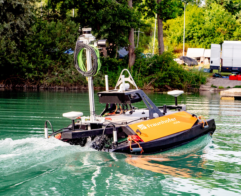
Able to operate autonomously, Fraunhofer’s USV has the potential to significantly reduce the cost of underwater surveying and charting. Image used courtesy of Fraunhofer
To help make underwater surveying more efficient and less costly, Fraunhofer’s vessel transits the surface and scans the underwater topography without human intervention or control. The company’s eventual goal is to provide accurate information and operate on a reliable enough schedule to deliver this critical data in real-time to support automated cargo and container ships now in research and development.
USV Ready to Scan the Environment: Above and Below the Water
Navigational charts depict the underwater topography, river banks, and the coasts of oceans and lakes. With this in mind, Fraunhofer developed its USV with above- and below-water scanning capabilities.
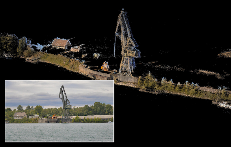
A 3D map of land features is useful for the safe navigation of ships in tight areas. Image used courtesy of Fraunhofer
Fraunhofer’s USV employs the company’s semi-automatic direction-finding system for rivers and lakes, identified by the German acronym TAPS. The system has a single central workstation on land to which it relays the information and data it gathers. Current underwater mapping capabilities are possible to a depth of 100 meters. Although this limits utility in deeper waters, as designed the USV has the potential to be used in coastal waters as well.
Autonomous Controls and Sensors
The craft is able to navigate autonomously using GPS and acceleration and yaw sensors in combination with a Doppler radar system. These all collaborate to give the vehicle its heading and course while operating. Laser scanners and cameras provide the USV with the ability to map surface features in order to create a 3D rendering of nearby surface topography. A multibeam sonar integrated directly into the sensors delivers the data to create an accurate high-fidelity 3D image of the bottom's topography.
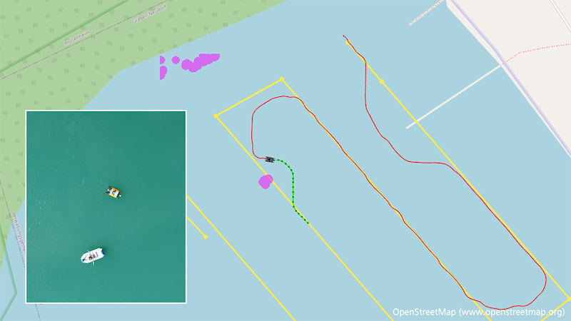
Deviation from the planned path as the USV avoids collision with another boat. Image used courtesy of Fraunhofer
When the vehicle is operating, a target area is determined prior to launch and the craft follows the path closely as it embarks on its scanning mission. However, the vehicle doesn’t dogmatically follow its pre-programmed course. To mitigate the potential of obstacles blocking navigation, and throwing the vessel off course, Fraunhofer developed software specifically designed to avoid collisions. The system re-directs the USV to avoid random obstacles, then automatically returns it to its original course.
Enabling Technology for Safer Seas
Fraunhofer’s USV is an enabling robotic technology designed to do what robots do best – making routine, rote, and dangerous tasks safer, more efficient, and less costly. It will be interesting to see where autonomous mapping technology takes the shipping industry, and its potential to make autonomous shipping a viable commercial reality.